Geolocate

Locloc topographic map

Click on the map to display elevation.

👉 Easily get elevation data in JSON, GeoTIFF and KML formats using Elevation API
Thank you for supporting this site ❤️
Make a donation

About this map

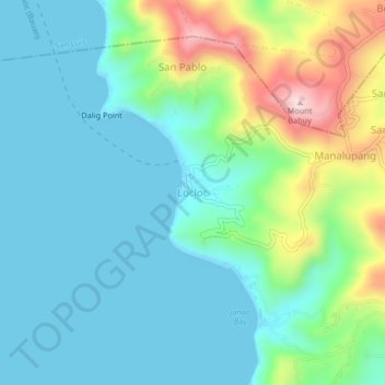
Name: Locloc topographic map, elevation, terrain.

Location: Locloc, Bauan, Batangas, Calabarzon, 4201, Philippines (13.77299 120.90128 13.81299 120.94128)

Average elevation: 285 ft

Minimum elevation: 0 ft

Maximum elevation: 1,184 ft

Gear up for your next adventure:

🪓Survival Multi‑Tool - Versatile tool for camp and trail tasks
🥩Freeze-Dried Meals - Nutritious and lightweight food for remote expeditions
🦺Reflective Outdoor Gear - Safety gear for low‑light conditions
🧺Microfiber Travel Towels - Compact and fast-drying towels for trail use
🛏️Cold Weather Sleeping Bag - Warm sleeping bag for cold conditions

As an Amazon Associate, this site earns from qualifying purchases at no extra cost to you.