
Bourget topographic map
Interactive map
Click on the map to display elevation.
About this map
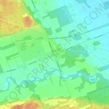
Name: Bourget topographic map, elevation, terrain.
Average elevation: 203 ft
Minimum elevation: 154 ft
Maximum elevation: 292 ft
Other topographic maps
Click on a map to view its topography, its elevation and its terrain.
Hammond
Canada > Ontario > Prescott and Russell Counties > Clarence-Rockland
Hammond, Clarence-Rockland, Prescott and Russell Counties, Eastern Ontario, Ontario, K0A 2A0, Canada
Average elevation: 233 ft
Clarence Creek
Canada > Ontario > Prescott and Russell Counties > Clarence-Rockland > Clarence Creek
Clarence Creek, Clarence-Rockland, Prescott and Russell Counties, Eastern Ontario, Ontario, K0A 1N0, Canada
Average elevation: 217 ft
Clarence Point
Canada > Ontario > Prescott and Russell Counties > Clarence-Rockland > Clarence Point
Clarence Point, Clarence-Rockland, Prescott and Russell Counties, Eastern Ontario, Ontario, K4K 1T2, Canada
Average elevation: 200 ft