
Thank you for supporting this site ❤️
Make a donation
Make a donation
Gear up for your next adventure:
As an Amazon Associate, this site earns from qualifying purchases at no extra cost to you.
Rudolphstein topographic map
Click on the map to display elevation.
Thank you for supporting this site ❤️
Make a donation
Make a donation
Gear up for your next adventure:
As an Amazon Associate, this site earns from qualifying purchases at no extra cost to you.
About this map
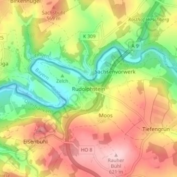
Name: Rudolphstein topographic map, elevation, terrain.
Location: Rudolphstein, Berg, Landkreis Hof, Bavaria, 95180, Germany (50.38933 11.75117 50.42933 11.79117)
Average elevation: 1,703 ft
Minimum elevation: 1,378 ft
Maximum elevation: 2,041 ft
Thank you for supporting this site ❤️
Make a donation
Make a donation
Gear up for your next adventure:
As an Amazon Associate, this site earns from qualifying purchases at no extra cost to you.
Other topographic maps
Click on a map to view its topography, its elevation and its terrain.