Geolocate

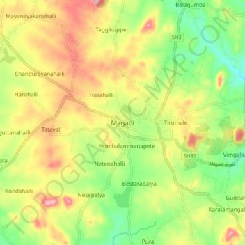
Magadi topographic map

Click on the map to display elevation.

Magadi

Magadi is located at 12°58′N 77°14′E / 12.97°N 77.23°E / 12.97; 77.23. It has an average elevation of 925 metres (3034 feet).

Wikipedia (CC-BY-SA 3.0)

About this map

Name: Magadi topographic map, elevation, terrain.

Location: Magadi, Magadi taluku, Bengaluru South, Karnataka, 562120, India (12.91674 77.18423 12.99674 77.26423)

Average elevation: 2,861 ft

Minimum elevation: 2,575 ft

Maximum elevation: 3,189 ft

Other topographic maps

Click on a map to view its topography, its elevation and its terrain.
Manchanabele

India > Karnataka > Magadi taluku

Average elevation: 2,530 ft

Gear up for your next adventure:

☕Camping Coffee Makers - Enjoy premium coffee at the summit or campsite
👟Trail Running Shoes - Lightweight shoes for trail runners
🔭Telescopic Hiking Pole - Adjustable pole for hiking stability
🥾Men's Hiking Boots - Durable, waterproof footwear for rugged terrain and steep inclines
🚪Portable Camp Chair - Foldable chair for comfort at camp

As an Amazon Associate, this site earns from qualifying purchases at no extra cost to you.