
Make a donation
Gear up for your next adventure:
As an Amazon Associate, this site earns from qualifying purchases at no extra cost to you.
Gohfeld topographic map
Click on the map to display elevation.
Make a donation
Gear up for your next adventure:
As an Amazon Associate, this site earns from qualifying purchases at no extra cost to you.
About this map
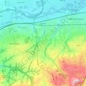
Name: Gohfeld topographic map, elevation, terrain.
Average elevation: 374 ft
Minimum elevation: 144 ft
Maximum elevation: 846 ft
Make a donation
Gear up for your next adventure:
As an Amazon Associate, this site earns from qualifying purchases at no extra cost to you.
Other topographic maps
Click on a map to view its topography, its elevation and its terrain.
Make a donation
Gear up for your next adventure:
As an Amazon Associate, this site earns from qualifying purchases at no extra cost to you.
Wasserschloss Ulenburg
Deutschland > Nordrhein-Westfalen > Kreis Herford > Löhne > Westscheid
Average elevation: 240 ft
Mahnen
Deutschland > Nordrhein-Westfalen > Kreis Herford > Löhne > Bischofshagen
Average elevation: 272 ft