
Make a donation
Gear up for your next adventure:
As an Amazon Associate, this site earns from qualifying purchases at no extra cost to you.
Naxos topographic map
Click on the map to display elevation.
Make a donation
Gear up for your next adventure:
As an Amazon Associate, this site earns from qualifying purchases at no extra cost to you.
Naxos
Naxos experiences both a Mediterranean climate (Csa) and a hot semi-arid climate (Köppen climate classification: BSh) depending on the location. According to the stations of the National Observatory of Athens, various locations in Naxos have a hot semi-arid climate. Inland areas of the island are much wetter and cooler in winter, owing to their higher elevation.
Make a donation
Gear up for your next adventure:
As an Amazon Associate, this site earns from qualifying purchases at no extra cost to you.
About this map
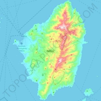
Name: Naxos topographic map, elevation, terrain.
Location: Naxos, Naxos Regional Unit, South Aegean, Aegean, Greece (36.91638 25.33292 37.20363 25.60650)
Average elevation: 367 ft
Minimum elevation: -3 ft
Maximum elevation: 3,235 ft
Make a donation
Gear up for your next adventure:
As an Amazon Associate, this site earns from qualifying purchases at no extra cost to you.
Other topographic maps
Click on a map to view its topography, its elevation and its terrain.
Φιλότι
Greece > Aegean > Naxos Regional Unit
Filoti (in Greek: Φιλώτι or Φιλότι; officially: Φιλότιον) is a semi-mountainous village of central Naxos, Greece, with a population of 1,477 residents (census 2011), located at the foot of Mt. Zas (1,004 m), at an altitude of 400 meters, about 18.2 kilometres (11.3 mi) from the city of…
Average elevation: 1,581 ft
Make a donation
Gear up for your next adventure:
As an Amazon Associate, this site earns from qualifying purchases at no extra cost to you.