
Make a donation
Gear up for your next adventure:
As an Amazon Associate, this site earns from qualifying purchases at no extra cost to you.
Witney topographic map
Click on the map to display elevation.
Make a donation
Gear up for your next adventure:
As an Amazon Associate, this site earns from qualifying purchases at no extra cost to you.
About this map
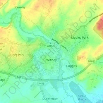
Name: Witney topographic map, elevation, terrain.
Location: Witney, West Oxfordshire, Oxfordshire, England, United Kingdom (51.77526 -1.52759 51.79955 -1.45705)
Average elevation: 302 ft
Minimum elevation: 236 ft
Maximum elevation: 417 ft
Make a donation
Gear up for your next adventure:
As an Amazon Associate, this site earns from qualifying purchases at no extra cost to you.
Other topographic maps
Click on a map to view its topography, its elevation and its terrain.
Shipton-under-Wychwood
United Kingdom > England > Oxfordshire > West Oxfordshire
Average elevation: 430 ft
Mount Skippett
United Kingdom > England > Oxfordshire > West Oxfordshire > Ramsden
Average elevation: 443 ft