
Make a donation
Gear up for your next adventure:
As an Amazon Associate, this site earns from qualifying purchases at no extra cost to you.
Twatt topographic map
Click on the map to display elevation.
Make a donation
Gear up for your next adventure:
As an Amazon Associate, this site earns from qualifying purchases at no extra cost to you.
About this map
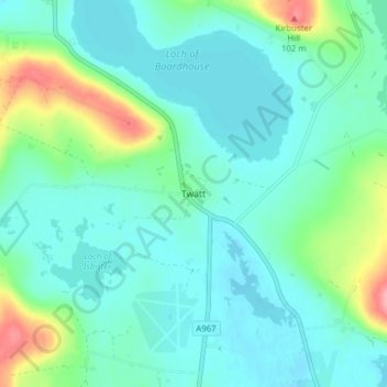
Name: Twatt topographic map, elevation, terrain.
Location: Twatt, Orkney Islands, Scotland, KW17 2LN, United Kingdom (59.08070 -3.29806 59.12070 -3.25806)
Average elevation: 108 ft
Minimum elevation: 36 ft
Maximum elevation: 358 ft
Make a donation
Gear up for your next adventure:
As an Amazon Associate, this site earns from qualifying purchases at no extra cost to you.
Other topographic maps
Click on a map to view its topography, its elevation and its terrain.
Orkney Islands
United Kingdom > Scotland > Orkney Islands
The southern group of islands surrounds Scapa Flow. Hoy, to the west, is the second largest of the Orkney Isles and Ward Hill at its northern end is the highest elevation in the archipelago. The Old Man of Hoy is a well-known seastack. Graemsay and Flotta are both linked by ferry to the Mainland and Hoy, and…
Average elevation: 30 ft
Make a donation
Gear up for your next adventure:
As an Amazon Associate, this site earns from qualifying purchases at no extra cost to you.
Sanday
United Kingdom > Scotland > Orkney Islands > Kettletoft
In the mid-17th century an annexe to Blaeu's Atlas Novus of Scotland recorded that Sanday's low lying topography meant that "shipwreck often occurs to those who sail there at night. The inhabitants of Sanday earnestly and often desire this to happen, so that they get a supply of material for fire from the…
Average elevation: 7 ft
Make a donation
Gear up for your next adventure:
As an Amazon Associate, this site earns from qualifying purchases at no extra cost to you.
Make a donation
Gear up for your next adventure:
As an Amazon Associate, this site earns from qualifying purchases at no extra cost to you.
Make a donation
Gear up for your next adventure:
As an Amazon Associate, this site earns from qualifying purchases at no extra cost to you.
South Ronaldsay
United Kingdom > Scotland > Orkney Islands
The cardinal points of the island are Ayre of Cara, by Churchill Barrier no. 4 (north), Grimness (east), Brough Ness, (south) and Hoxa Head, (west). The highest elevation is Ward Hill, which reaches 118 metres (387 ft). This name is common one in Orkney for the highest point on an island and comes from the…
Average elevation: 39 ft
Stronsay
United Kingdom > Scotland > Orkney Islands > Whitehall
Stronsay (/ˈstrɒnziː/) is an island in Orkney, Scotland. It is known as Orkney's 'Island of Bays', owing to an irregular shape with miles of coastline, with three large bays separated by two isthmuses: St Catherine's Bay to the west, the Bay of Holland to the south and Mill Bay to the east. Stronsay is…
Average elevation: 13 ft
Make a donation
Gear up for your next adventure:
As an Amazon Associate, this site earns from qualifying purchases at no extra cost to you.
Orkney Islands
United Kingdom > Scotland > Orkney Islands
The southern group of islands surrounds Scapa Flow. Hoy, to the west, is the second largest of the Orkney Isles and Ward Hill at its northern end is the highest elevation in the archipelago. The Old Man of Hoy is a well-known seastack. Graemsay and Flotta are both linked by ferry to the Mainland and Hoy, and…
Average elevation: 30 ft
Sanday
United Kingdom > Scotland > Orkney Islands > Kettletoft
In the mid-17th century an annexe to Blaeu's Atlas Novus of Scotland recorded that Sanday's low lying topography meant that "shipwreck often occurs to those who sail there at night. The inhabitants of Sanday earnestly and often desire this to happen, so that they get a supply of material for fire from the…
Average elevation: 7 ft
Make a donation
Gear up for your next adventure:
As an Amazon Associate, this site earns from qualifying purchases at no extra cost to you.
Make a donation
Gear up for your next adventure:
As an Amazon Associate, this site earns from qualifying purchases at no extra cost to you.