
Make a donation
Gear up for your next adventure:
As an Amazon Associate, this site earns from qualifying purchases at no extra cost to you.
Willmersbach topographic map
Click on the map to display elevation.
Make a donation
Gear up for your next adventure:
As an Amazon Associate, this site earns from qualifying purchases at no extra cost to you.
About this map
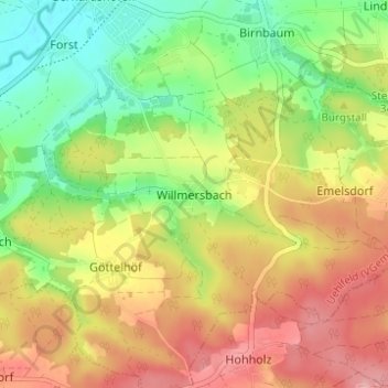
Name: Willmersbach topographic map, elevation, terrain.
Average elevation: 1,106 ft
Minimum elevation: 902 ft
Maximum elevation: 1,312 ft
Make a donation
Gear up for your next adventure:
As an Amazon Associate, this site earns from qualifying purchases at no extra cost to you.
Other topographic maps
Click on a map to view its topography, its elevation and its terrain.
97215
Germany > Bavaria > Landkreis Neustadt an der Aisch-Bad Windsheim > Uffenheim
Average elevation: 1,155 ft
Emskirchen
Germany > Bavaria > Landkreis Neustadt an der Aisch-Bad Windsheim
Average elevation: 1,204 ft
Neustadt an der Aisch
Germany > Bavaria > Landkreis Neustadt an der Aisch-Bad Windsheim
Average elevation: 1,155 ft
Illesheim
Germany > Bavaria > Landkreis Neustadt an der Aisch-Bad Windsheim
Average elevation: 1,161 ft
Make a donation
Gear up for your next adventure:
As an Amazon Associate, this site earns from qualifying purchases at no extra cost to you.
Emskirchen
Germany > Bavaria > Landkreis Neustadt an der Aisch-Bad Windsheim
Average elevation: 1,204 ft
Weigenheim
Germany > Bavaria > Landkreis Neustadt an der Aisch-Bad Windsheim
Average elevation: 1,138 ft
Markt Erlbach
Germany > Bavaria > Landkreis Neustadt an der Aisch-Bad Windsheim
Average elevation: 1,240 ft
Diespeck
Germany > Bavaria > Landkreis Neustadt an der Aisch-Bad Windsheim
Average elevation: 1,093 ft
Make a donation
Gear up for your next adventure:
As an Amazon Associate, this site earns from qualifying purchases at no extra cost to you.
Trautskirchen
Germany > Bavaria > Landkreis Neustadt an der Aisch-Bad Windsheim
Average elevation: 1,286 ft