
Make a donation
Gear up for your next adventure:
As an Amazon Associate, this site earns from qualifying purchases at no extra cost to you.
McClure topographic map
Click on the map to display elevation.
Make a donation
Gear up for your next adventure:
As an Amazon Associate, this site earns from qualifying purchases at no extra cost to you.
About this map
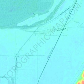
Name: McClure topographic map, elevation, terrain.
Location: McClure, Alexander County, Illinois, United States (37.29204 -89.44949 37.33476 -89.39585)
Average elevation: 338 ft
Minimum elevation: 322 ft
Maximum elevation: 492 ft
Alexander County trails, hiking, mountain biking, running and outdoor activities
Make a donation
Gear up for your next adventure:
As an Amazon Associate, this site earns from qualifying purchases at no extra cost to you.
Other topographic maps
Click on a map to view its topography, its elevation and its terrain.
Cairo
United States > Illinois > Alexander County > Cairo > Cairo
The city is located at the confluence of the Ohio and Mississippi rivers. Fort Defiance, a Civil War camp, was built here in 1862 by Union General Ulysses S. Grant to control strategic access to the rivers, and launch and supply his successful campaigns south. Cairo has the lowest elevation of any location in…
Average elevation: 312 ft