
Thank you for supporting this site ❤️
Make a donation
Make a donation
Gear up for your next adventure:
As an Amazon Associate, this site earns from qualifying purchases at no extra cost to you.
Mixquiahuala topographic map
Click on the map to display elevation.
Thank you for supporting this site ❤️
Make a donation
Make a donation
Gear up for your next adventure:
As an Amazon Associate, this site earns from qualifying purchases at no extra cost to you.
About this map
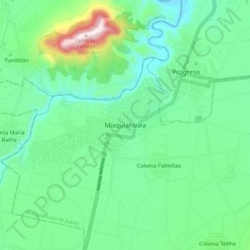
Name: Mixquiahuala topographic map, elevation, terrain.
Location: Mixquiahuala, Mixquiahuala de Juárez, Hidalgo, 42700, México (20.19073 -99.24980 20.27073 -99.16980)
Average elevation: 6,594 ft
Minimum elevation: 6,122 ft
Maximum elevation: 8,054 ft
Thank you for supporting this site ❤️
Make a donation
Make a donation
Gear up for your next adventure:
As an Amazon Associate, this site earns from qualifying purchases at no extra cost to you.