
Bridge of Don topographic map
Interactive map
Click on the map to display elevation.
About this map
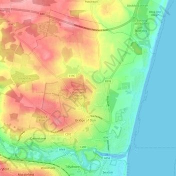
Name: Bridge of Don topographic map, elevation, terrain.
Location: Bridge of Don, Aberdeen City, Scotland, United Kingdom (57.17175 -2.15474 57.22744 -2.05912)
Average elevation: 154 ft
Minimum elevation: -7 ft
Maximum elevation: 335 ft
Other topographic maps
Click on a map to view its topography, its elevation and its terrain.
Northfield
United Kingdom > Scotland > Aberdeen City
Northfield, Aberdeen City, Scotland, United Kingdom
Average elevation: 299 ft
Brimmond Hill
United Kingdom > Scotland > Aberdeen City
Brimmond Hill, Aberdeen City, Scotland, AB15 8SJ, United Kingdom
Average elevation: 541 ft
Peterculter
United Kingdom > Scotland > Aberdeen City
Peterculter, Aberdeen City, Scotland, AB14 0SG, United Kingdom
Average elevation: 200 ft
Kingswells
United Kingdom > Scotland > Aberdeen City
Kingswells, Aberdeen City, Scotland, United Kingdom
Average elevation: 495 ft
Torry
United Kingdom > Scotland > Aberdeen City
Torry, Aberdeen City, Scotland, United Kingdom
Average elevation: 89 ft