
Brimmond Hill topographic map
Interactive map
Click on the map to display elevation.
About this map
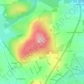
Name: Brimmond Hill topographic map, elevation, terrain.
Average elevation: 541 ft
Minimum elevation: 341 ft
Maximum elevation: 863 ft
Brimmond Hill is a hill in Aberdeen, Scotland. The summit is the highest point within the Aberdeen City council area, at an elevation of 266 m (873 ft).
Other topographic maps
Click on a map to view its topography, its elevation and its terrain.
Northfield
United Kingdom > Scotland > Aberdeen City
Northfield, Aberdeen City, Scotland, United Kingdom
Average elevation: 299 ft
Peterculter
United Kingdom > Scotland > Aberdeen City
Peterculter, Aberdeen City, Scotland, AB14 0SG, United Kingdom
Average elevation: 200 ft
Kingswells
United Kingdom > Scotland > Aberdeen City
Kingswells, Aberdeen City, Scotland, United Kingdom
Average elevation: 495 ft
Bridge of Don
United Kingdom > Scotland > Aberdeen City
Bridge of Don, Aberdeen City, Scotland, United Kingdom
Average elevation: 154 ft
Torry
United Kingdom > Scotland > Aberdeen City
Torry, Aberdeen City, Scotland, United Kingdom
Average elevation: 89 ft