
Make a donation
Gear up for your next adventure:
As an Amazon Associate, this site earns from qualifying purchases at no extra cost to you.
Zell (Mosel) topographic map
Click on the map to display elevation.
Make a donation
Gear up for your next adventure:
As an Amazon Associate, this site earns from qualifying purchases at no extra cost to you.
Zell (Mosel)
Zell is an hour's drive from both Koblenz and Trier, more or less halfway between these two cities. The nearest town going towards Koblenz is Cochem, and the nearest two going towards Trier are Traben-Trarbach and Bernkastel-Kues. To both Frankfurt-Hahn Airport on the Hunsrück and the spa town of Bad Bertrich in the Voreifel it is half an hour's drive. The parts of town lying on the river, the Old Town, Kaimt and Merl, are at an elevation of roughly 100 m above sea level on a remarkable bow in the river Moselle, known as the Zeller Hamm.
Make a donation
Gear up for your next adventure:
As an Amazon Associate, this site earns from qualifying purchases at no extra cost to you.
About this map
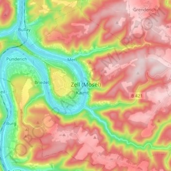
Name: Zell (Mosel) topographic map, elevation, terrain.
Average elevation: 942 ft
Minimum elevation: 292 ft
Maximum elevation: 1,503 ft
Make a donation
Gear up for your next adventure:
As an Amazon Associate, this site earns from qualifying purchases at no extra cost to you.
Other topographic maps
Click on a map to view its topography, its elevation and its terrain.
Moselhöhe Ediger-Eller
Germany > Rhineland-Palatinate > Landkreis Cochem-Zell > Ediger-Eller
Average elevation: 935 ft