
Thank you for supporting this site ❤️
Make a donation
Make a donation
Gear up for your next adventure:
As an Amazon Associate, this site earns from qualifying purchases at no extra cost to you.
Poutaha topographic map
Click on the map to display elevation.
Thank you for supporting this site ❤️
Make a donation
Make a donation
Gear up for your next adventure:
As an Amazon Associate, this site earns from qualifying purchases at no extra cost to you.
About this map
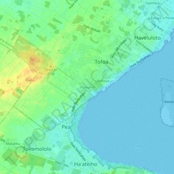
Name: Poutaha topographic map, elevation, terrain.
Location: Poutaha, Tofoa, Vahe Kolomotu'a, Tongatapu, Tonga (-21.18100 -175.25045 -21.14100 -175.21045)
Average elevation: 30 ft
Minimum elevation: 0 ft
Maximum elevation: 95 ft
Thank you for supporting this site ❤️
Make a donation
Make a donation
Gear up for your next adventure:
As an Amazon Associate, this site earns from qualifying purchases at no extra cost to you.