Geolocate

Taganga topographic map

Click on the map to display elevation.

About this map

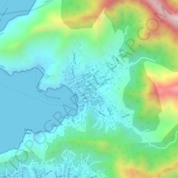
Name: Taganga topographic map, elevation, terrain.

Location: Taganga, Santa Marta, Magdalena, Colombia (11.26157 -74.19386 11.27471 -74.18241)

Average elevation: 381 ft

Minimum elevation: 0 ft

Maximum elevation: 1,407 ft

Other topographic maps

Click on a map to view its topography, its elevation and its terrain.

Mutanyi

Colombia > Magdalena > Santa Marta

Average elevation: 2,621 ft

El Pegoso

Colombia > Magdalena > Santa Marta

Average elevation: 899 ft

Santa Marta

Colombia > Magdalena > Santa Marta

Average elevation: 702 ft

Gear up for your next adventure:

🥤Water Filter Bottle - All‑in‑one filter bottle for safe hydration
🧭Map Reading Tools - Tools and kits for map navigation
🏔️Mountain Trail Maps - High‑detail maps for popular peaks
☀️Outdoor Sunscreen - High protection sunscreen for outdoor activities
🛠️Backpacking Tool Kit - Essential toolkit for outdoor repairs

As an Amazon Associate, this site earns from qualifying purchases at no extra cost to you.