Geolocate

Tulcán topographic map

Click on the map to display elevation.

About this map

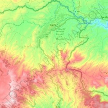
Name: Tulcán topographic map, elevation, terrain.

Location: Tulcán, Carchi, Ecuador (0.67802 -77.82353 0.85090 -77.66383)

Average elevation: 10,210 ft

Minimum elevation: 8,773 ft

Maximum elevation: 11,959 ft

Other topographic maps

Click on a map to view its topography, its elevation and its terrain.

Cordillera de Chiltazón

Ecuador > Carchi > Tulcán

Average elevation: 4,577 ft

Gear up for your next adventure:

🥄Camping Utensil Set - Lightweight utensils for outdoor meals
🥩Freeze-Dried Meals - Nutritious and lightweight food for remote expeditions
🗃️Trail First Aid Kit - Essential kit for outdoor injuries and emergencies
🪵Folding Camp Saw - Compact saw for wood and campsite work
📻Weather Alert Radios - Stay informed of storm risks while off-the-grid

As an Amazon Associate, this site earns from qualifying purchases at no extra cost to you.