
Thank you for supporting this site ❤️
Make a donation
Make a donation
Gear up for your next adventure:
As an Amazon Associate, this site earns from qualifying purchases at no extra cost to you.
Verbier topographic map
Click on the map to display elevation.
Thank you for supporting this site ❤️
Make a donation
Make a donation
Gear up for your next adventure:
As an Amazon Associate, this site earns from qualifying purchases at no extra cost to you.
About this map
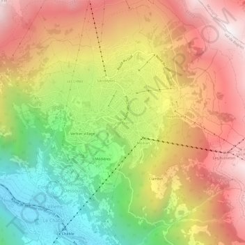
Name: Verbier topographic map, elevation, terrain.
Location: Verbier, Val de Bagnes, Entremont, Wallis, 1934, Switzerland (46.07610 7.20868 46.11610 7.24868)
Average elevation: 5,335 ft
Minimum elevation: 2,628 ft
Maximum elevation: 7,871 ft
Thank you for supporting this site ❤️
Make a donation
Make a donation
Gear up for your next adventure:
As an Amazon Associate, this site earns from qualifying purchases at no extra cost to you.