Geolocate

Elstra topographic map

Click on the map to display elevation.

About this map

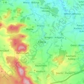
Name: Elstra topographic map, elevation, terrain.

Location: Elstra, Bautzen, Sachsen, 01920, Deutschland (51.18052 14.09503 51.26052 14.17503)

Average elevation: 801 ft

Minimum elevation: 541 ft

Maximum elevation: 1,417 ft

Gear up for your next adventure:

🕶️Glacier Sunglasses - Side shields to protect eyes from high-altitude snow glare
🛠️Outdoor Gear Repair Kit - Essential tools to fix gear on the trail
🧷Carabiner Set - Durable clips for gear attachment
🛶Inflatable Kayak - Portable kayak for rivers, lakes, and expeditions
🪑Ultralight Camp Chairs - Portable seating for resting after a long day of mapping

As an Amazon Associate, this site earns from qualifying purchases at no extra cost to you.