Geolocate

Scanno topographic map

Click on the map to display elevation.

About this map

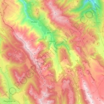
Name: Scanno topographic map, elevation, terrain.

Location: Scanno, L'Aquila, Abruzzo, Italy (41.80381 13.82461 41.96932 13.99453)

Average elevation: 5,115 ft

Minimum elevation: 2,028 ft

Maximum elevation: 7,385 ft

Other topographic maps

Click on a map to view its topography, its elevation and its terrain.

Piccola Svizzera

Italy > Abruzzo > L'Aquila > Tagliacozzo

Average elevation: 3,330 ft

Castiglione

Italy > Abruzzo > L'Aquila > Montereale

Average elevation: 3,645 ft

Colli

Italy > Abruzzo > L'Aquila > Barete

Average elevation: 2,746 ft

Cerro

Italy > Abruzzo > L'Aquila > Borgo San Lorenzo

Average elevation: 2,126 ft

Campo di Fano

Italy > Abruzzo > L'Aquila > Prezza

Average elevation: 1,371 ft

Marignano

Italy > Abruzzo > L'Aquila > Montereale

Average elevation: 2,877 ft

Colle

Italy > Abruzzo > L'Aquila > Vallecupa

Average elevation: 2,392 ft

Borgo San Lorenzo

Italy > Abruzzo > L'Aquila

Average elevation: 1,991 ft

Colle

Italy > Abruzzo > L'Aquila > Vallecupa

Average elevation: 2,392 ft

Gear up for your next adventure:

🚪Portable Camp Chair - Foldable chair for comfort at camp
📦Dry Bags Set - Waterproof storage for electronics and clothes
📖Nature Tracking Books - Learn to track wildlife and terrain
🪶Fire Starter Kit - Reliable fire starter for survival and camping
📚Navigation Handbooks - Master the art of reading topographic maps and using a compass

As an Amazon Associate, this site earns from qualifying purchases at no extra cost to you.