
Winston topographic map
Click on the map to display elevation.
About this map
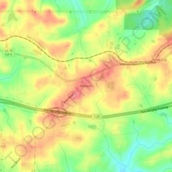
Name: Winston topographic map, elevation, terrain.
Location: Winston, Douglas County, Georgia, 30133, United States (33.70511 -84.84494 33.74511 -84.80494)
Average elevation: 1,115 ft
Minimum elevation: 968 ft
Maximum elevation: 1,240 ft
Douglas County trails, hiking, mountain biking, running and outdoor activities
Other topographic maps
Click on a map to view its topography, its elevation and its terrain.
Douglasville
United States > Georgia > Douglas County
Located along a natural rise in the topography, Douglasville was originally known as "Skint Chestnut." The name was derived from a large tree used by Native Americans as a landmark; it was stripped of its bark so as to be more conspicuous.
Average elevation: 1,017 ft