
Make a donation
Gear up for your next adventure:
As an Amazon Associate, this site earns from qualifying purchases at no extra cost to you.
Starkville topographic map
Click on the map to display elevation.
Make a donation
Gear up for your next adventure:
As an Amazon Associate, this site earns from qualifying purchases at no extra cost to you.
About this map
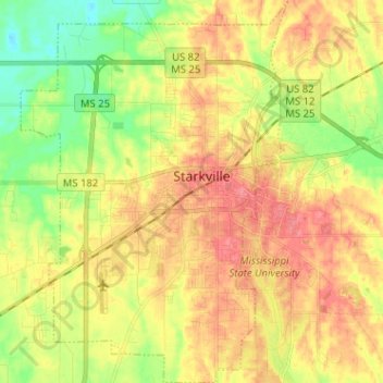
Name: Starkville topographic map, elevation, terrain.
Average elevation: 305 ft
Minimum elevation: 190 ft
Maximum elevation: 407 ft
Oktibbeha County trails, hiking, mountain biking, running and outdoor activities
Make a donation
Gear up for your next adventure:
As an Amazon Associate, this site earns from qualifying purchases at no extra cost to you.
Other topographic maps
Click on a map to view its topography, its elevation and its terrain.
The Cotton District
United States > Mississippi > Oktibbeha County > Starkville
Average elevation: 348 ft
Make a donation
Gear up for your next adventure:
As an Amazon Associate, this site earns from qualifying purchases at no extra cost to you.
Country Club Subdivision
United States > Mississippi > Oktibbeha County > Starkville
Average elevation: 331 ft
Whispering Pines
United States > Mississippi > Oktibbeha County > Starkville
Average elevation: 299 ft
The Cotton District
United States > Mississippi > Oktibbeha County > Starkville
Average elevation: 348 ft