Geolocate

Xino topographic map

Click on the map to display elevation.

About this map

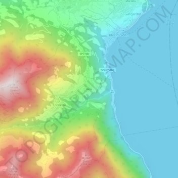
Name: Xino topographic map, elevation, terrain.

Location: Xino, Fonteno, Bergamo, Lombardy, 24060, Italy (45.74136 10.00975 45.78136 10.04975)

Average elevation: 1,680 ft

Minimum elevation: 581 ft

Maximum elevation: 3,963 ft

Gear up for your next adventure:

📖Nature Tracking Books - Learn to track wildlife and terrain
🪵Folding Camp Saw - Compact saw for wood and campsite work
👟Men's Trail Runners - Lightweight footwear for fast-paced exploration and light hiking
🎒Gear Packing Cubes - Organize your backpack efficiently
🦟Ultrasonic Repellers - Create a bug-free zone at your camp or rest stop

As an Amazon Associate, this site earns from qualifying purchases at no extra cost to you.