Geolocate

Joinville topographic map

Click on the map to display elevation.

About this map
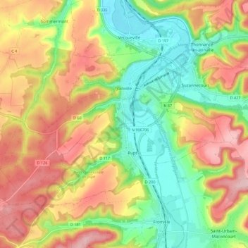
Name: Joinville topographic map, elevation, terrain.

Location: Joinville, Saint-Dizier, Haute-Marne, Grand Est, Metropolitan France, 52300, France (48.40870 5.07225 48.45664 5.18247)

Average elevation: 876 ft

Minimum elevation: 574 ft

Maximum elevation: 1,214 ft

Other topographic maps

Click on a map to view its topography, its elevation and its terrain.

Soôte

France > Grand Est > Haute-Marne > Longeau-Percey

Average elevation: 1,132 ft

Beaucharmoy

France > Grand Est > Haute-Marne > Le Châtelet-sur-Meuse

Average elevation: 1,243 ft

Montesson

France > Grand Est > Haute-Marne > Pierremont-sur-Amance

Average elevation: 928 ft

Ferme Febvre

France > Grand Est > Haute-Marne > Le Châtelet-sur-Meuse

Average elevation: 1,309 ft

Saint-Mars

France > Grand Est > Haute-Marne > Louvemont

Average elevation: 499 ft

Le Canar

France > Grand Est > Haute-Marne > Saints-Geosmes

Average elevation: 1,457 ft

Gear up for your next adventure:

📚Navigation Handbooks - Master the art of reading topographic maps and using a compass
📻Weather Alert Radios - Stay informed of storm risks while off-the-grid
🧣Hiking Neck Gaiter - Multi‑use neck protection for outdoor weather
🎒Waterproof Dry Bags - Keep your electronics and maps dry inside your pack
🥤Water Filter Bottle - All‑in‑one filter bottle for safe hydration

As an Amazon Associate, this site earns from qualifying purchases at no extra cost to you.