Geolocate

Chilpancingo topographic map

Click on the map to display elevation.

Chilpancingo

The climate of Chilpancingo is classified as a tropical savanna climate ("Aw"). There is some moderation due to high elevation, but high temperatures are still in the upper 20s °C (80s °F) for most of the year.

Wikipedia (CC-BY-SA 3.0)

About this map

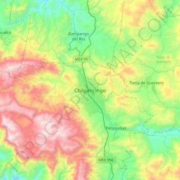
Name: Chilpancingo topographic map, elevation, terrain.

Location: Chilpancingo, Chilpancingo de los Bravo, Guerrero, 39000, Mexico (17.39421 -99.66484 17.71421 -99.34484)

Average elevation: 5,338 ft

Minimum elevation: 2,726 ft

Maximum elevation: 9,606 ft

Gear up for your next adventure:

🧯Emergency Survival Kit - All‑in‑one survival essentials for the backcountry
🧭Hiking Compass - Precision compass for reliable navigation in the wilderness
🧥Waterproof Jacket for Hiking - Breathable and rugged rain jacket for outdoor excursions
🌄Hiking Binoculars - Compact binoculars for scenic views and trail spotting
🧴Hand Sanitizer - Keep hands clean while hiking

As an Amazon Associate, this site earns from qualifying purchases at no extra cost to you.