Geolocate

Jacksonville topographic map

Click on the map to display elevation.

About this map

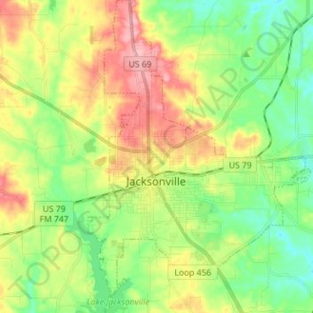
Name: Jacksonville topographic map, elevation, terrain.

Location: Jacksonville, Cherokee County, Texas, 75766, United States (31.91861 -95.29804 32.02550 -95.20822)

Average elevation: 499 ft

Minimum elevation: 341 ft

Maximum elevation: 728 ft

Cherokee County trails, hiking, mountain biking, running and outdoor activities

Other topographic maps

Click on a map to view its topography, its elevation and its terrain.

Pryor Mountain

United States > Texas > Cherokee County

Average elevation: 518 ft

Mount Selman

United States > Texas > Cherokee County

Average elevation: 568 ft

Mount Selman

United States > Texas > Cherokee County

Average elevation: 568 ft

Maydelle

United States > Texas > Cherokee County > Maydelle

Average elevation: 427 ft

Gear up for your next adventure:

🧭Compass with Lanyard - Easy‑carry compass for navigation
📷Action Camera - Capture your outdoor adventures in HD
🌄Hiking Binoculars - Compact binoculars for scenic views and trail spotting
📌Outdoor GPS Map App - Apps and devices for digital topographic navigation
🎒Trekking Poles - Sturdy poles for balance and stability on rough terrain

As an Amazon Associate, this site earns from qualifying purchases at no extra cost to you.