Geolocate

Maruggio topographic map

Click on the map to display elevation.

Maruggio

The territory of Maruggio extends for 48.33 square kilometres (18.66 mi2) on a level land, with some low-rise hills in the north part of the territory, which reaches a maximum elevation of 101 metres (331 ft).

Wikipedia (CC-BY-SA 3.0)

About this map

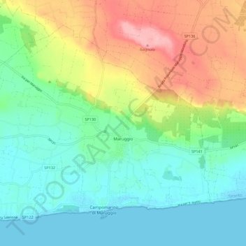
Name: Maruggio topographic map, elevation, terrain.

Location: Maruggio, Taranto, Apulia, Italy (40.29447 17.50180 40.36074 17.61082)

Average elevation: 138 ft

Minimum elevation: -7 ft

Maximum elevation: 413 ft

Other topographic maps

Click on a map to view its topography, its elevation and its terrain.

Marinara

Italy > Apulia > Taranto > Mottola

Average elevation: 856 ft

Saturo

Italy > Apulia > Taranto > Leporano

Average elevation: 39 ft

Gear up for your next adventure:

🧭Pro Hiking Compasses - High-accuracy liquid-filled compasses for topographic orientation
😴Insulated Sleeping Pads - Compact and warm pads for high-elevation camping
🔭Stargazing Telescopes - Perfect for camping in low-light pollution areas shown on maps
🔭Telescopic Hiking Pole - Adjustable pole for hiking stability
🏥Hiking First Aid Kits - Comprehensive medical kits for remote trail injuries

As an Amazon Associate, this site earns from qualifying purchases at no extra cost to you.