
Make a donation
Gear up for your next adventure:
As an Amazon Associate, this site earns from qualifying purchases at no extra cost to you.
Sokolica topographic map
Click on the map to display elevation.
Make a donation
Gear up for your next adventure:
As an Amazon Associate, this site earns from qualifying purchases at no extra cost to you.
About this map
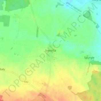
Name: Sokolica topographic map, elevation, terrain.
Average elevation: 174 ft
Minimum elevation: 105 ft
Maximum elevation: 266 ft
Make a donation
Gear up for your next adventure:
As an Amazon Associate, this site earns from qualifying purchases at no extra cost to you.
Other topographic maps
Click on a map to view its topography, its elevation and its terrain.
Bartoszyce
Poland > Warmian-Masurian Voivodeship > Bartoszyce County > Bartoszyce
Bartoszyce lies on the left shore of river Łyna River in a valley, approximately 90 kilometres (56 miles) east of Elbląg and 55 kilometres (34 miles) south of Kaliningrad, at an altitude of 3 metres (9.8 feet) above sea level.
Average elevation: 184 ft