
Eiserfeld topographic map
Interactive map
Click on the map to display elevation.
About this map
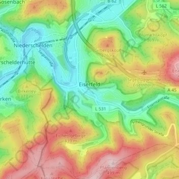
Name: Eiserfeld topographic map, elevation, terrain.
Average elevation: 1,089 ft
Minimum elevation: 702 ft
Maximum elevation: 1,624 ft
Other topographic maps
Click on a map to view its topography, its elevation and its terrain.
Siegen
Duitsland > Noordrijn-Westfalen > Kreis Siegen-Wittgenstein > Siegen
Average elevation: 1,316 ft