
Thank you for supporting this site ❤️
Make a donation
Make a donation
Gear up for your next adventure:
As an Amazon Associate, this site earns from qualifying purchases at no extra cost to you.
Topton topographic map
Click on the map to display elevation.
Thank you for supporting this site ❤️
Make a donation
Make a donation
Gear up for your next adventure:
As an Amazon Associate, this site earns from qualifying purchases at no extra cost to you.
About this map
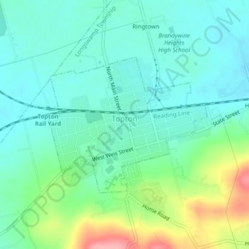
Name: Topton topographic map, elevation, terrain.
Location: Topton, Berks County, Pennsylvania, United States (40.49535 -75.71209 40.51011 -75.68951)
Average elevation: 528 ft
Minimum elevation: 430 ft
Maximum elevation: 797 ft
Thank you for supporting this site ❤️
Make a donation
Make a donation
Gear up for your next adventure:
As an Amazon Associate, this site earns from qualifying purchases at no extra cost to you.
Other topographic maps
Click on a map to view its topography, its elevation and its terrain.
Dale
United States > Pennsylvania > Berks County > Washington Township > Dale
Average elevation: 774 ft