
Thank you for supporting this site ❤️
Make a donation
Make a donation
Gear up for your next adventure:
As an Amazon Associate, this site earns from qualifying purchases at no extra cost to you.
Ngewa topographic map
Click on the map to display elevation.
Thank you for supporting this site ❤️
Make a donation
Make a donation
Gear up for your next adventure:
As an Amazon Associate, this site earns from qualifying purchases at no extra cost to you.
About this map
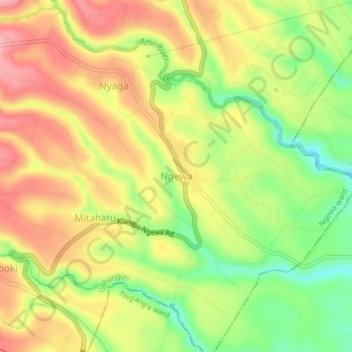
Name: Ngewa topographic map, elevation, terrain.
Location: Ngewa, Ngewa ward, Githunguri, Kiambu, Central Kenya, Kenya (-1.11362 36.84487 -1.07362 36.88487)
Average elevation: 5,466 ft
Minimum elevation: 5,226 ft
Maximum elevation: 5,673 ft
Thank you for supporting this site ❤️
Make a donation
Make a donation
Gear up for your next adventure:
As an Amazon Associate, this site earns from qualifying purchases at no extra cost to you.