Geolocate

Ranton topographic map

Click on the map to display elevation.

About this map

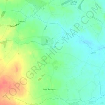
Name: Ranton topographic map, elevation, terrain.

Location: Ranton, Stafford, Staffordshire, England, United Kingdom (52.79685 -2.24495 52.82758 -2.19470)

Average elevation: 338 ft

Minimum elevation: 272 ft

Maximum elevation: 453 ft

Other topographic maps

Click on a map to view its topography, its elevation and its terrain.

Hooks Green

United Kingdom > England > Staffordshire > Stafford

Average elevation: 505 ft

Aston-by-Stone

United Kingdom > England > Staffordshire > Stafford

Average elevation: 354 ft

Beffcote

United Kingdom > England > Staffordshire > Stafford > Gnosall

Average elevation: 325 ft

Great Haywood

United Kingdom > England > Staffordshire > Stafford

Average elevation: 295 ft

Woodseaves

United Kingdom > England > Staffordshire > Stafford

Average elevation: 400 ft

Marston

United Kingdom > England > Staffordshire > Stafford

Average elevation: 344 ft

Standon Mill

United Kingdom > England > Staffordshire > Stafford

Average elevation: 390 ft

Outwoods

United Kingdom > England > Staffordshire > Stafford

Average elevation: 289 ft

Moreton

United Kingdom > England > Staffordshire > Stafford

Average elevation: 312 ft

Bradley

United Kingdom > England > Staffordshire > Stafford

Average elevation: 361 ft

Hopton

United Kingdom > England > Staffordshire > Stafford

Average elevation: 348 ft

Aqualate Mere

United Kingdom > England > Staffordshire > Stafford > Forton

Average elevation: 243 ft

St James Green

United Kingdom > England > Staffordshire > Stafford

Average elevation: 407 ft

Meir Heath

United Kingdom > England > Staffordshire > Stafford

Average elevation: 656 ft

Little Haywood

United Kingdom > England > Staffordshire > Stafford

Average elevation: 328 ft

Moddershall

United Kingdom > England > Staffordshire > Stafford

Average elevation: 607 ft

Milford

United Kingdom > England > Staffordshire > Stafford > Milford

Average elevation: 338 ft

Knightley

United Kingdom > England > Staffordshire > Stafford > Gnosall > Knightley

Average elevation: 417 ft

Yarnfield

United Kingdom > England > Staffordshire > Stafford

Average elevation: 354 ft

Beech

United Kingdom > England > Staffordshire > Stafford > Beech

Average elevation: 502 ft

Gear up for your next adventure:

🥄Camping Utensil Set - Lightweight utensils for outdoor meals
🔌Solar Panel Charger - Charge gear sustainably outdoors
🥘Titanium Cookware - Durable, featherlight pots and pans for backpacking
GPS Sports Watch - GPS watch for running, hiking and training
👓Polarized Sunglasses - Outdoor sunglasses for glare reduction

As an Amazon Associate, this site earns from qualifying purchases at no extra cost to you.