
Make a donation
Gear up for your next adventure:
As an Amazon Associate, this site earns from qualifying purchases at no extra cost to you.
Tanahun topographic map
Click on the map to display elevation.
Make a donation
Gear up for your next adventure:
As an Amazon Associate, this site earns from qualifying purchases at no extra cost to you.
About this map
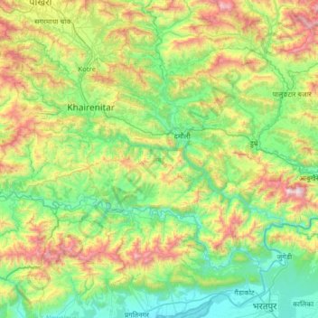
Name: Tanahun topographic map, elevation, terrain.
Location: Tanahun, Gandaki Province, Nepal (27.74127 83.93656 28.12954 84.55924)
Average elevation: 2,270 ft
Minimum elevation: 502 ft
Maximum elevation: 6,801 ft
Make a donation
Gear up for your next adventure:
As an Amazon Associate, this site earns from qualifying purchases at no extra cost to you.
Other topographic maps
Click on a map to view its topography, its elevation and its terrain.
Jomsom
Nepal > Gandaki Province > Mustang
Jomsom (Nepali: जोमसोम), (Ward No. 4 of Gharpajhong Rural Municipality) also known as Dzongsam (New Fort), is the centre of Gharapjhong rural municipality in Mustang district and a former independent village development committee situated at an altitude of about 2,700 metres (8,900 ft) in Gandaki…
Average elevation: 10,043 ft
Manaslu
Nepal > Gandaki Province > Gorkha
The Manaslu region offers a variety of trekking options. The popular Manaslu trekking route of 177 kilometres (110 mi) skirts the Manaslu massif over the pass down to Annapurna. The Nepalese Government only permitted trekking on this circuit in 1991. The trekking trail follows an ancient salt-trading route…
Average elevation: 23,192 ft
Make a donation
Gear up for your next adventure:
As an Amazon Associate, this site earns from qualifying purchases at no extra cost to you.
Make a donation
Gear up for your next adventure:
As an Amazon Associate, this site earns from qualifying purchases at no extra cost to you.