Geolocate

Walworth topographic map

Click on the map to display elevation.

About this map

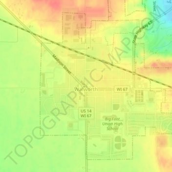
Name: Walworth topographic map, elevation, terrain.

Location: Walworth, Walworth County, Wisconsin, 53184, United States (42.52005 -88.60934 42.54316 -88.57971)

Average elevation: 997 ft

Minimum elevation: 886 ft

Maximum elevation: 1,073 ft

Walworth County trails, hiking, mountain biking, running and outdoor activities

Other topographic maps

Click on a map to view its topography, its elevation and its terrain.

Troy Center

United States > Wisconsin > Walworth County

Average elevation: 883 ft

Tibbets

United States > Wisconsin > Walworth County

Average elevation: 925 ft

Abells Corners

United States > Wisconsin > Walworth County

Average elevation: 902 ft

Millard

United States > Wisconsin > Walworth County

Average elevation: 928 ft

Lake Como

United States > Wisconsin > Walworth County > Lake Como

Average elevation: 928 ft

Gear up for your next adventure:

🗺️NatGeo Topo Maps - High-quality waterproof printed topographic maps of US Parks
🔦Powerful Headlamps - Ultra-bright hands-free lighting for night navigation
🧭Pro Hiking Compasses - High-accuracy liquid-filled compasses for topographic orientation
📚USA Hiking Guide Books - Top trail guides and map books
🧺Microfiber Travel Towels - Compact and fast-drying towels for trail use

As an Amazon Associate, this site earns from qualifying purchases at no extra cost to you.