Geolocate

84371 topographic map

Click on the map to display elevation.

About this map

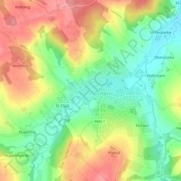
Name: 84371 topographic map, elevation, terrain.

Location: 84371, Triftern, Landkreis Rottal-Inn, Bayern, Deutschland (48.39567 13.00185 48.39577 13.00195)

Average elevation: 1,394 ft

Minimum elevation: 1,237 ft

Maximum elevation: 1,572 ft

Other topographic maps

Click on a map to view its topography, its elevation and its terrain.

Unterreitzing

Deutschland > Bayern > Landkreis Rottal-Inn > Triftern

Average elevation: 1,526 ft

Gear up for your next adventure:

🪶Compact Camp Shovel - Folding shovel for campsite tasks
🛡️Bear Spray Outdoor - Protection in bear country hikes
🗺️NatGeo Topo Maps - High-quality waterproof printed topographic maps of US Parks
🔊Portable Camp Speaker - Music and alerts at camp
🧯Portable Fire Pit - Compact fire pit for camping spots

As an Amazon Associate, this site earns from qualifying purchases at no extra cost to you.