
Severance topographic map
Click on the map to display elevation.
About this map
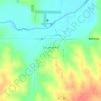
Name: Severance topographic map, elevation, terrain.
Location: Severance, Doniphan County, Kansas, United States (39.76221 -95.25238 39.77045 -95.24529)
Average elevation: 955 ft
Minimum elevation: 883 ft
Maximum elevation: 1,076 ft
Doniphan County trails, hiking, mountain biking, running and outdoor activities
Other topographic maps
Click on a map to view its topography, its elevation and its terrain.
Highland Elementary School
United States > Kansas > Doniphan County > Highland
Average elevation: 1,027 ft