Geolocate

Henley topographic map

Click on the map to display elevation.

About this map

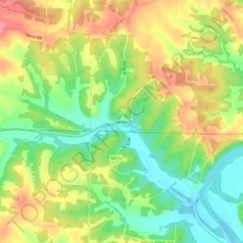
Name: Henley topographic map, elevation, terrain.

Location: Henley, Cole County, Missouri, 65040, United States (38.32448 -92.34240 38.36448 -92.30240)

Average elevation: 692 ft

Minimum elevation: 538 ft

Maximum elevation: 863 ft

Cole County trails, hiking, mountain biking, running and outdoor activities

Other topographic maps

Click on a map to view its topography, its elevation and its terrain.

Taos

United States > Missouri > Cole County

Average elevation: 715 ft

Lohman

United States > Missouri > Cole County

Average elevation: 715 ft

Centertown

United States > Missouri > Cole County

Average elevation: 801 ft

Wardsville

United States > Missouri > Cole County

Average elevation: 669 ft

Gear up for your next adventure:

🔥Camping Stove - Portable stove for camping and backcountry cooking
🔭Telescopic Hiking Pole - Adjustable pole for hiking stability
📌Outdoor GPS Map App - Apps and devices for digital topographic navigation
👖Convertible Hiking Pants - Versatile zip-off pants for changing altitudes and temperatures
🔭Compact Binoculars - HD vision for scouting terrain and identifying distant landmarks

As an Amazon Associate, this site earns from qualifying purchases at no extra cost to you.