
Bloomington topographic map
Click on the map to display elevation.
About this map
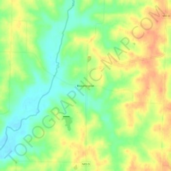
Name: Bloomington topographic map, elevation, terrain.
Location: Bloomington, Macon County, Missouri, United States (39.77698 -92.58019 39.81698 -92.54019)
Average elevation: 823 ft
Minimum elevation: 751 ft
Maximum elevation: 892 ft
Macon County trails, hiking, mountain biking, running and outdoor activities
Other topographic maps
Click on a map to view its topography, its elevation and its terrain.