Geolocate

Tigua topographic map

Click on the map to display elevation.

About this map

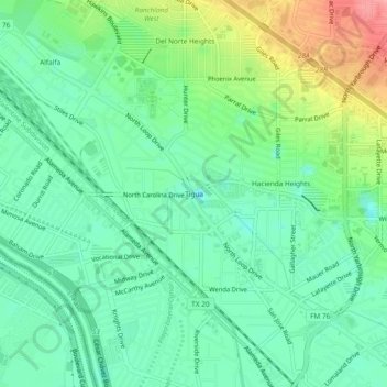
Name: Tigua topographic map, elevation, terrain.

Location: Tigua, El Paso, El Paso County, Texas, 79915, United States (31.72178 -106.38415 31.76178 -106.34415)

Average elevation: 3,724 ft

Minimum elevation: 3,609 ft

Maximum elevation: 3,970 ft

Other topographic maps

Click on a map to view its topography, its elevation and its terrain.

Memorial Park

United States > Texas > El Paso County > El Paso

Average elevation: 3,829 ft

Mc Arthur Park

United States > Texas > El Paso County > El Paso > Cielo Vista

Average elevation: 3,934 ft

The Bite Food Park

United States > Texas > El Paso County > El Paso

Average elevation: 3,924 ft

Gear up for your next adventure:

📦Dry Bags Set - Waterproof storage for electronics and clothes
📌Outdoor GPS Map App - Apps and devices for digital topographic navigation
🪄Magnetic Compass - Accurate compass for navigation
🔭Compact Binoculars - HD vision for scouting terrain and identifying distant landmarks
🔥Fast-Boil Camping Stoves - Efficient cooking systems for quick trail meals

As an Amazon Associate, this site earns from qualifying purchases at no extra cost to you.