Geolocate

Baileyton topographic map

Click on the map to display elevation.

About this map

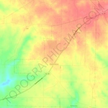
Name: Baileyton topographic map, elevation, terrain.

Location: Baileyton, Cullman County, Alabama, United States (34.24273 -86.63814 34.29086 -86.58632)

Average elevation: 968 ft

Minimum elevation: 807 ft

Maximum elevation: 1,063 ft

Cullman County trails, hiking, mountain biking, running and outdoor activities

Other topographic maps

Click on a map to view its topography, its elevation and its terrain.

Duck River

United States > Alabama > Cullman County

Average elevation: 771 ft

Trimble

United States > Alabama > Cullman County

Average elevation: 607 ft

Arkadelphia

United States > Alabama > Cullman County

Average elevation: 423 ft

Crane Hill

United States > Alabama > Cullman County

Average elevation: 705 ft

Hanceville

United States > Alabama > Cullman County > Hanceville

Average elevation: 584 ft

Gear up for your next adventure:

🦶Hiking Gaiters - Keep debris and water out of your boots
🔥Plasma Lighters - Windproof lighters that work in any weather condition
🌎3D Topographic Globes - Raised relief globes for a tactile understanding of geography
🧭Pro Hiking Compasses - High-accuracy liquid-filled compasses for topographic orientation
🎒Gear Packing Cubes - Organize your backpack efficiently

As an Amazon Associate, this site earns from qualifying purchases at no extra cost to you.