Geolocate

Brazos Point topographic map

Click on the map to display elevation.

About this map

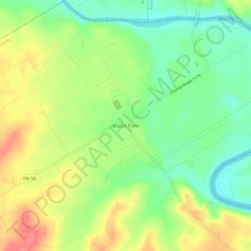
Name: Brazos Point topographic map, elevation, terrain.

Location: Brazos Point, Bosque County, Texas, United States (32.16709 -97.63919 32.20709 -97.59919)

Average elevation: 640 ft

Minimum elevation: 538 ft

Maximum elevation: 758 ft

Bosque County trails, hiking, mountain biking, running and outdoor activities

Other topographic maps

Click on a map to view its topography, its elevation and its terrain.

Walnut Springs

United States > Texas > Bosque County

Average elevation: 942 ft

Cranfills Gap

United States > Texas > Bosque County

Average elevation: 997 ft

Iredell

United States > Texas > Bosque County

Average elevation: 912 ft

Meridian

United States > Texas > Bosque County

Average elevation: 804 ft

Morgan

United States > Texas > Bosque County

Average elevation: 745 ft

Clifton

United States > Texas > Bosque County

Average elevation: 715 ft

Gear up for your next adventure:

🧭Outdoor Navigation Book - Learn advanced navigation skills
🏕️Family Camping Gear - Essentials for group camping trips
👟Men's Trail Runners - Lightweight footwear for fast-paced exploration and light hiking
🥘Titanium Cookware - Durable, featherlight pots and pans for backpacking
🦶Hiking Gaiters - Keep debris and water out of your boots

As an Amazon Associate, this site earns from qualifying purchases at no extra cost to you.