Geolocate

Madison Lake topographic map

Click on the map to display elevation.

About this map

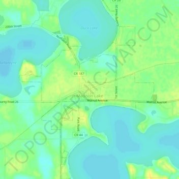
Name: Madison Lake topographic map, elevation, terrain.

Location: Madison Lake, Blue Earth County, Minnesota, 56063, United States (44.18823 -93.83453 44.22286 -93.79813)

Average elevation: 1,033 ft

Minimum elevation: 1,004 ft

Maximum elevation: 1,073 ft

Blue Earth County trails, hiking, mountain biking, running and outdoor activities

Other topographic maps

Click on a map to view its topography, its elevation and its terrain.

Garden City

United States > Minnesota > Blue Earth County

Average elevation: 974 ft

Benning

United States > Minnesota > Blue Earth County > Mankato

Average elevation: 843 ft

Beauford

United States > Minnesota > Blue Earth County

Average elevation: 1,004 ft

Gear up for your next adventure:

🚗GPS Dash Cams - Record your scenic drives through mountain passes and canyons
🛏️Cold Weather Sleeping Bag - Warm sleeping bag for cold conditions
🏔️Mountain Trail Maps - High‑detail maps for popular peaks
🪶Thermal Camp Blanket - Extra warmth for cold nights
❄️Traction Cleats - Prevent slips on icy trails during winter hikes

As an Amazon Associate, this site earns from qualifying purchases at no extra cost to you.