
Thank you for supporting this site ❤️
Make a donation
Make a donation
Gear up for your next adventure:
As an Amazon Associate, this site earns from qualifying purchases at no extra cost to you.
Armañanzas topographic map
Click on the map to display elevation.
Thank you for supporting this site ❤️
Make a donation
Make a donation
Gear up for your next adventure:
As an Amazon Associate, this site earns from qualifying purchases at no extra cost to you.
About this map
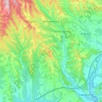
Name: Armañanzas topographic map, elevation, terrain.
Location: Armañanzas, Montejurra, Navarre, Espagne (42.48675 -2.30687 42.58008 -2.27239)
Average elevation: 1,614 ft
Minimum elevation: 1,237 ft
Maximum elevation: 2,582 ft
Thank you for supporting this site ❤️
Make a donation
Make a donation
Gear up for your next adventure:
As an Amazon Associate, this site earns from qualifying purchases at no extra cost to you.