Geolocate

Downing topographic map

Click on the map to display elevation.

About this map

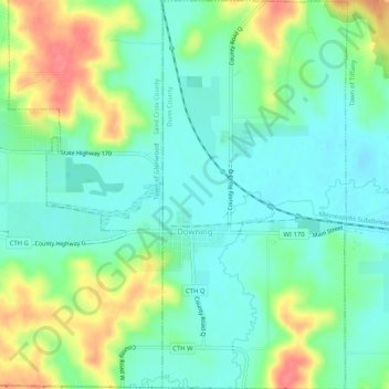
Name: Downing topographic map, elevation, terrain.

Location: Downing, Dunn County, Wisconsin, 54734, United States (45.03159 -92.13643 45.06789 -92.11192)

Average elevation: 1,037 ft

Minimum elevation: 958 ft

Maximum elevation: 1,191 ft

Dunn County trails, hiking, mountain biking, running and outdoor activities

Other topographic maps

Click on a map to view its topography, its elevation and its terrain.

Graytown

United States > Wisconsin > Dunn County

Average elevation: 1,129 ft

Caryville

United States > Wisconsin > Dunn County

Average elevation: 791 ft

Downsville

United States > Wisconsin > Dunn County

Average elevation: 837 ft

Rock Falls

United States > Wisconsin > Dunn County

Average elevation: 869 ft

Wilson Park

United States > Wisconsin > Dunn County > Menomonie

Average elevation: 876 ft

Canary Island

United States > Wisconsin > Dunn County > Menomonie

Average elevation: 1,014 ft

Gear up for your next adventure:

🔭Telescopic Hiking Pole - Adjustable pole for hiking stability
🎒Gear Packing Cubes - Organize your backpack efficiently
🪶Thermal Camp Blanket - Extra warmth for cold nights
🧭Map Reading Tools - Tools and kits for map navigation
🚑Emergency Bivvies - Heat-reflective sleeping bags for survival situations

As an Amazon Associate, this site earns from qualifying purchases at no extra cost to you.