
Castanea topographic map
Click on the map to display elevation.
About this map
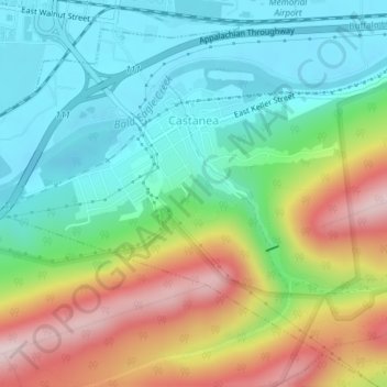
Name: Castanea topographic map, elevation, terrain.
Location: Castanea, Clinton County, Pennsylvania, 17726, United States (41.11028 -77.45198 41.12869 -77.41487)
Average elevation: 935 ft
Minimum elevation: 522 ft
Maximum elevation: 1,696 ft
Clinton County trails, hiking, mountain biking, running and outdoor activities
Other topographic maps
Click on a map to view its topography, its elevation and its terrain.
Nittany Valley
United States > Pennsylvania > Clinton County > Porter Township
Nittany Valley is in the western part of the Ridge and Valley province of the Appalachian Mountains. During the Appalachian orogeny, the sedimentary rock layers folded up into the Nittany Arch anticline. The arch was an ancient Himalayan scale mountain that towered above what is now the valley. The oldest rock…
Average elevation: 1,188 ft
Keating
United States > Pennsylvania > Clinton County > East Keating Township
Average elevation: 1,194 ft
Bear Swamp
United States > Pennsylvania > Clinton County > Beech Creek Township > Bear Swamp
Average elevation: 1,227 ft
Youngdale
United States > Pennsylvania > Clinton County > Wayne Township > Youngdale
Average elevation: 764 ft
Nippenose Mountain
United States > Pennsylvania > Clinton County > Crawford Township
Average elevation: 1,345 ft
North Bend
United States > Pennsylvania > Clinton County > Chapman Township
Average elevation: 1,224 ft
Beech Creek
United States > Pennsylvania > Clinton County > Beech Creek Township
Average elevation: 1,178 ft
Clintondale
United States > Pennsylvania > Clinton County > Porter Township > Lamar
Average elevation: 988 ft
Rauchtown
United States > Pennsylvania > Clinton County > Crawford Township
Average elevation: 1,125 ft
Tylersville
United States > Pennsylvania > Clinton County > Logan Township
Average elevation: 1,493 ft
Woolrich
United States > Pennsylvania > Clinton County > Pine Creek Township
Average elevation: 951 ft
Grove Hill
United States > Pennsylvania > Clinton County > West Keating Township
Average elevation: 1,522 ft