
Álamos topographic map
Interactive map
Click on the map to display elevation.
About this map
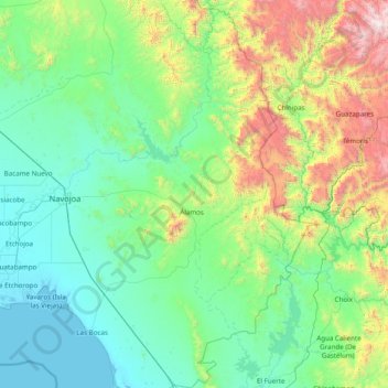
Name: Álamos topographic map, elevation, terrain.
Location: Álamos, Sonora, México (26.39018 -109.25997 27.77572 -108.42427)
Average elevation: 1,604 ft
Minimum elevation: -7 ft
Maximum elevation: 9,144 ft
Other topographic maps
Click on a map to view its topography, its elevation and its terrain.
Setajaqui (Setajaqui del Rio)
Setajaqui (Setajaqui del Rio), Álamos, Sonora, México
Average elevation: 1,020 ft