
Álamos topographic map
Interactive map
Click on the map to display elevation.
About this map
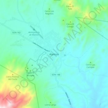
Name: Álamos topographic map, elevation, terrain.
Location: Álamos, Sonora, 85767, México (26.98269 -108.97460 27.06269 -108.89460)
Average elevation: 1,640 ft
Minimum elevation: 1,020 ft
Maximum elevation: 4,541 ft
Other topographic maps
Click on a map to view its topography, its elevation and its terrain.
Setajaqui (Setajaqui del Rio)
Setajaqui (Setajaqui del Rio), Álamos, Sonora, México
Average elevation: 1,020 ft