
Make a donation
Gear up for your next adventure:
As an Amazon Associate, this site earns from qualifying purchases at no extra cost to you.
Cahuachi topographic map
Click on the map to display elevation.
Make a donation
Gear up for your next adventure:
As an Amazon Associate, this site earns from qualifying purchases at no extra cost to you.
About this map
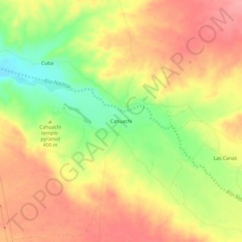
Name: Cahuachi topographic map, elevation, terrain.
Location: Cahuachi, Nasca, Ica, Perú (-14.83916 -75.12455 -14.79916 -75.08455)
Average elevation: 1,302 ft
Minimum elevation: 1,109 ft
Maximum elevation: 1,440 ft
Make a donation
Gear up for your next adventure:
As an Amazon Associate, this site earns from qualifying purchases at no extra cost to you.
Other topographic maps
Click on a map to view its topography, its elevation and its terrain.
Gigante
Las pampas de Jumana están situadas a una altitud de 330 m s. n. m. y mantienen una temperatura media anual de 25 grados centígrados en una de las zonas más secas del planeta, lo que ayuda a conservar los dibujos. El aire caliente actúa como un "colchón" que impide que las líneas se borren porque obliga…
Average elevation: 1,745 ft