Geolocate

Siayan topographic map

Click on the map to display elevation.

About this map

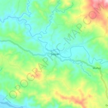
Name: Siayan topographic map, elevation, terrain.

Location: Siayan, Zamboanga del Norte, Zamboanga Peninsula, Philippines (8.21139 123.07426 8.29139 123.15426)

Average elevation: 630 ft

Minimum elevation: 59 ft

Maximum elevation: 2,021 ft

Other topographic maps

Click on a map to view its topography, its elevation and its terrain.

Sibuco

Philippines > Zamboanga del Norte

Average elevation: 581 ft

Sibuco

Philippines > Zamboanga del Norte

Average elevation: 581 ft

Dapitan River

Philippines > Zamboanga del Norte

Average elevation: 961 ft

Gear up for your next adventure:

🎒Day Hiking Backpack - Lightweight backpack perfect for day trips and outdoor adventures
🪵Folding Camp Saw - Compact saw for wood and campsite work
GPS Sports Watch - GPS watch for running, hiking and training
🎁Geography Themed Gifts - Unique gift ideas for map lovers and geography enthusiasts
🧭Orienteering Set - Complete compass and map reading kit

As an Amazon Associate, this site earns from qualifying purchases at no extra cost to you.