Geolocate

Qingyang County topographic map

Click on the map to display elevation.

About this map

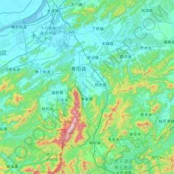
Name: Qingyang County topographic map, elevation, terrain.

Location: Qingyang County, Chizhou, Anhui, 242800, China (30.32303 117.67761 30.84597 118.12954)

Average elevation: 594 ft

Minimum elevation: 0 ft

Maximum elevation: 4,173 ft

Gear up for your next adventure:

🧥Men's Rain Shells - Premium waterproof and breathable jackets for mountain weather
🎁Geography Themed Gifts - Unique gift ideas for map lovers and geography enthusiasts
🌎3D Topographic Globes - Raised relief globes for a tactile understanding of geography
📡GPS Antenna Upgrade - Enhance GPS reception in remote terrain
⛑️Personal Locator Beacon - Safety beacon for emergencies

As an Amazon Associate, this site earns from qualifying purchases at no extra cost to you.